Yellow Warning - Cold
4:10 a.m. EST Friday 30 January 2026

Impact Level: Moderate

Forecast Confidence: High


Frigid temperatures expected early this morning.

What:
Wind chills of minus 30 to minus 35.

When:
Early this morning.

Cover up. Frostbite can develop within minutes on exposed skin, especially with wind chill.

If it's too cold for you to stay outside, it's too cold for your pet to stay outside.

Watch for colour changes on fingers and toes, pain, numbness, a tingling sensation, or swelling. If present, move indoors and begin warming.

Please continue to monitor alerts and forecasts issued by Environment Canada. To report severe weather, send an email to ONstorm@ec.gc.ca or post reports on X using #ONStorm.

For more information about the alerting program, please visit: https://www.canada.ca/en/services/environment/weather/severeweather/weather-alerts/colour-coded-alerts.

In effect for:
  • London - Parkhill - Eastern Middlesex County

CLICK for Environment Canada Ontario South Alerts
spacer
Updated: @ 30/01/2026 08:40 - next update at 08:45  
Summary / Temperature Wind Rain Outlook
Currently: -20.4, Max: -18.0, Min: -22.8 -20.4°C
Warmer 0.4°C than last hour.

Extreme Cold

Feels like: -20°C

24-hr difference
-6.2°CColder 6.2°C than yesterday at this time.
  Today Yesterday
High: -18°C
00:00
-10.8°C
12:10
Low: -22.8°C
04:43
-18°C
23:58
 Calm ---
0
Gust:
0 km/h
0 Bft - Calm
Today: 8.5 km/h 02:19
Gust Month: 60.0 km/h January 9
Rain Today: 0 mm
Rain Rate (/hr): 0 mm
Rain Yesterday: 0 mm
This Month: 30.4 mm
Season Total: 30.4 mm
13 days since last rain.
Tonight
A few flurries
A few flurries
Humidity & Barometer Almanac Moon
Humidity: 77 % Increased 2.0% since last hour.
Dew Point: -26.6°C Increased 0.6°C since last hour.
Barometer: 1029.77 hPa Rising 0.4  hPa/hr
Baro Trend: Rising slowly
Sunrise: 07:43
Sunset: 17:36
Moonset: 06:18
Moonrise: 14:51
Waxing Gibbous
Waxing Gibbous, Moon at 12 days in cycle
93%
Illuminated
UV Index Solar Radiation
   0.0    None
High: 0.0 @ 00:00
32 W/m2
High: 44 @  08:28
 EC Weather Forecast  - Outlook: Today & Tonight
Today
Chance of flurries (40%)
Chance of flurries

Max: -12°C
EC forecast: Mainly cloudy with 40 percent chance of flurries. Wind becoming northwest 20 km/h near noon. High minus 12. Wind chill minus 32 this morning and minus 20 this afternoon. Risk of frostbite. UV index 1 or low.
Davis VP+ forecast: Partly cloudy with little temperature change.
 
Tonight
A few flurries
A few flurries

Min: -20°C
EC forecast: A few flurries ending near midnight then mainly cloudy. Local amount 2 cm. Wind northwest 20 km/h becoming light near midnight. Low minus 20. Wind chill minus 22 this evening and minus 27 overnight.


For longer term forecast click here
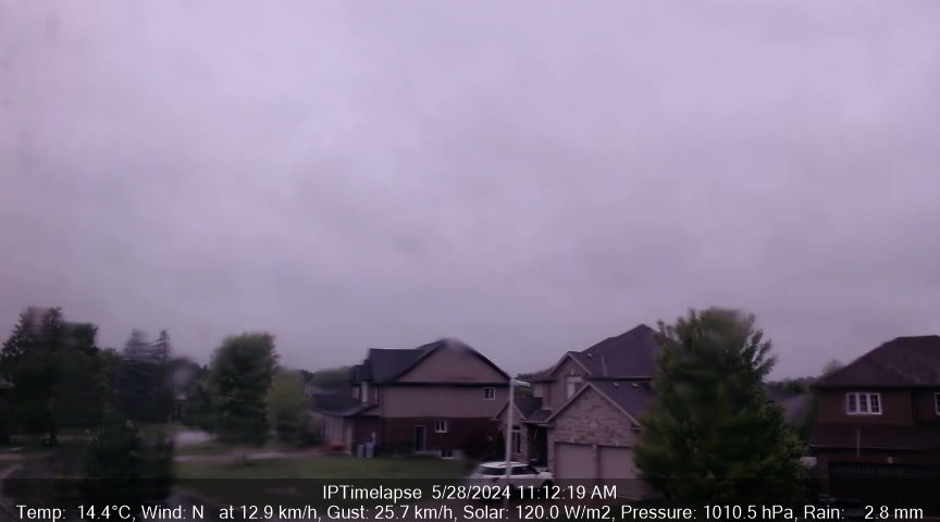


Click Refresh or [F5]
KomokaWeather Webcam Image Updated Every 1 Minute - Press [F5] or Refresh


Canada Logo Davis Logo Cumulus Logo B-L Logo WU Logo PWS Logo
WEatherForYou Logo WOW Logo Weather Bug Logo EC Logo
WX Forum Logo Yawcam Logo Webcams.Travel Logo
CWOP Logo CWOP Logo AWEKAS Logo Ontario Weather Network Logo Environment Canada Canwarn Logo


KomokaWeather banner